
From road to street: Taragoña
The objective is to recover the space and its character as a slow lane, silencing the infrastructure to give back the protagonism to the people who live and work there.


The AC-305 in front of Bar Xuntanza.
Brief historical overview
Taragoña has a long history, the parish of Taragoña became independent from Rianxo and constituted its own Town Council approximately in 1821; this fact was due to the high population density of the parish. In 1933 Taragoña was the most populated parish in the whole judicial district of Padrón.
The economic development of Taragoña is partly thanks to its location. In the 1920s, Taragoña gained economic momentum and had emerging companies, such as, for example, the pyrotechnical industry. According to Xosé Ramón Brea Rei, Taragoña had a strategic location as a shipping point for the mining industry of San Finx and shipment of fabrics and articles from Vilagarcía.
For many years it was the scene of the various fairs of livestock and other products, managing to gain importance. Although with the suspension of the parish fairs and the implementation of a single municipal fair in Rianxo, it lost its presence in this type of events.
Campo de Pazos is a key piece in Taragoña, gathering some of the most important elements for the history of the parish of Taragoña, such as the parish church of San Salvador de Taragoña, the eucalyptus trees planted around 1875; the Café La Unión, a place where agrarian and union meetings were organized or the old cinema of Taragoña. Another of the most emblematic buildings of Campo de Pazos is the Rosalía de Castro School, today a school and cultural center and formerly "Escola de americanos" created by the Sociedade Hijos de Taragoña, based in Argentina in 1922.
(References from the book "Taragoña na historia. 90 aniversario da escola Rosalía de Castro", written in 2021 by Xosé Ramón Brea Rei from Taragoña)
Year
2022
Promoter
Xuntade Galicia - Conselleria de infraestruturas e mobilidade - Axencia Galega de Infraestruturas
Localization
Taragoña, Rianxo, A Coruña
Team and collaborators
Fundación RIA
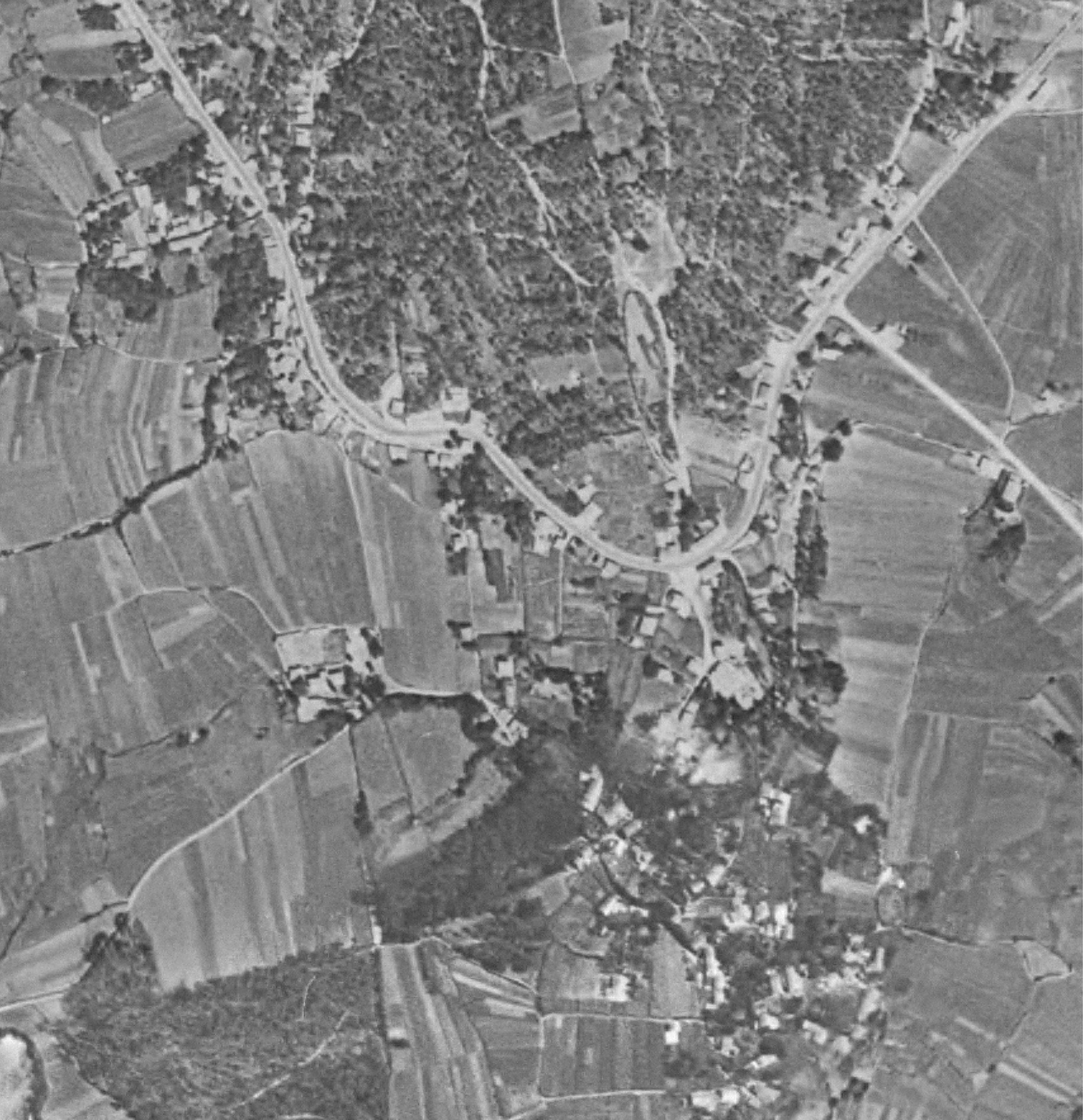

Historical evolution of Taragoña.
Field work
The analysis of the section of the AC-305 in Taragoña gathers the information provided in the official public database, local and international experts and field work. The latter is a fundamental part as it complements the existing information and provides the analysis with greater precision.
Manual data collection
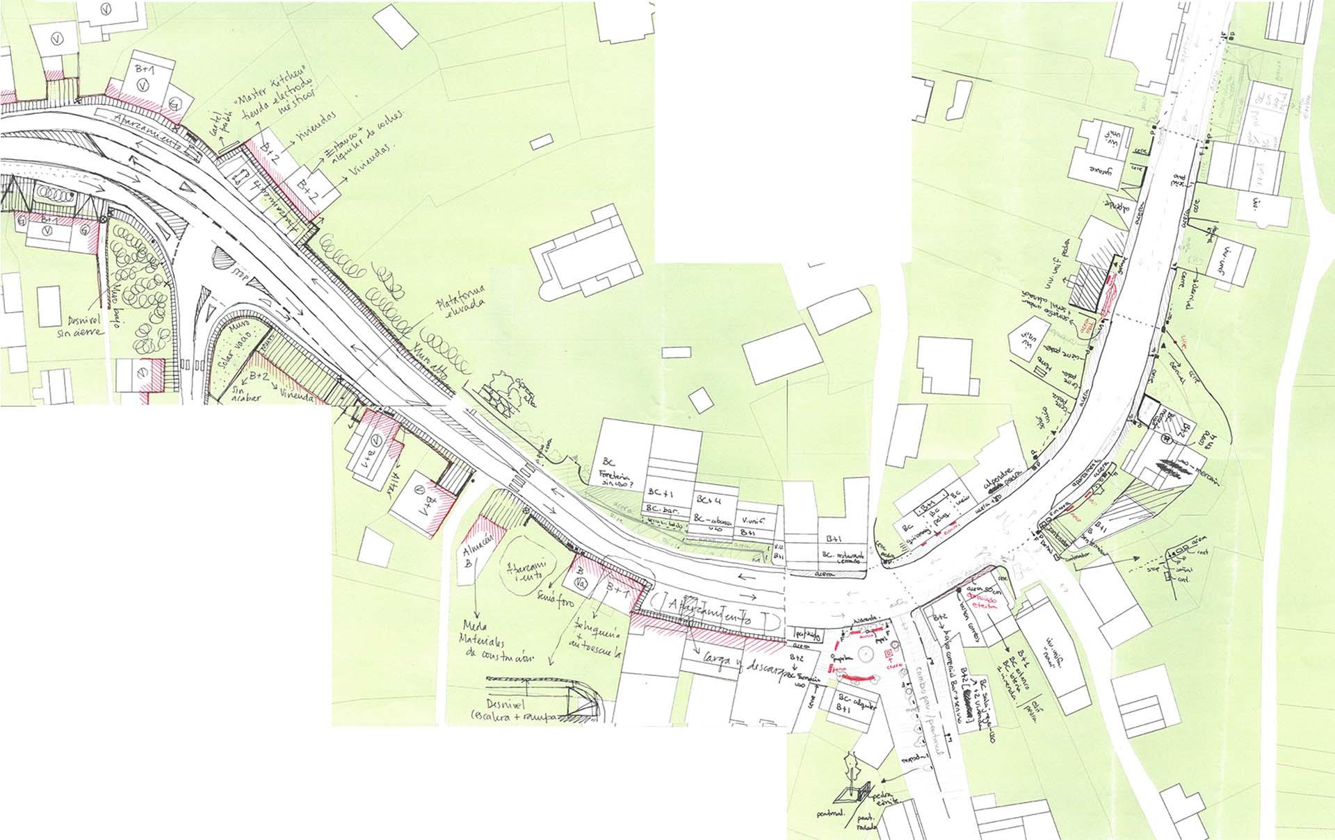
For the collection of manual information, several visits were made to Taragoña. The first ones had the objective of approaching the place, in a more generic way. The environment is toured, both on foot and by car, to identify and experience first-hand the existing problems. The relevant information to know and explain the reality of the AC-305 in Taragoña is photographed with camera and drone.
As the number of field visits increased, the information gathered became more accurate. In addition to the photographs, the entire route of the road is redrawn by hand in order to make an exhaustive and detailed approach of the current state. This work allows us to generate a cartography faithful to reality, as well as to know the state of the buildings and stores.
Public participation processes
Through the celebration of a public event, the aim is to encourage debate with the local population to incorporate subjective criteria on the safety of the road and to reflect on the heritage, urban and identity values of the environment. The event allows to reflect on the section that runs through Taragoña at the height of Campo de Pazos and that has been chosen for future actions by the Fundación RIA and the Axencia Galega de Infraestruturas.
The event had two parts:
- A 20-minute presentation by Fundación RIA, describing the context of the study and the principles on which it is based. Through photographs and videos, some of the conflicts identified in the AC-305 as it passes through Taragoña and the potential for improvement of the environment are presented.
- A debate with the attendees on mobility and public space in the region and the municipality.
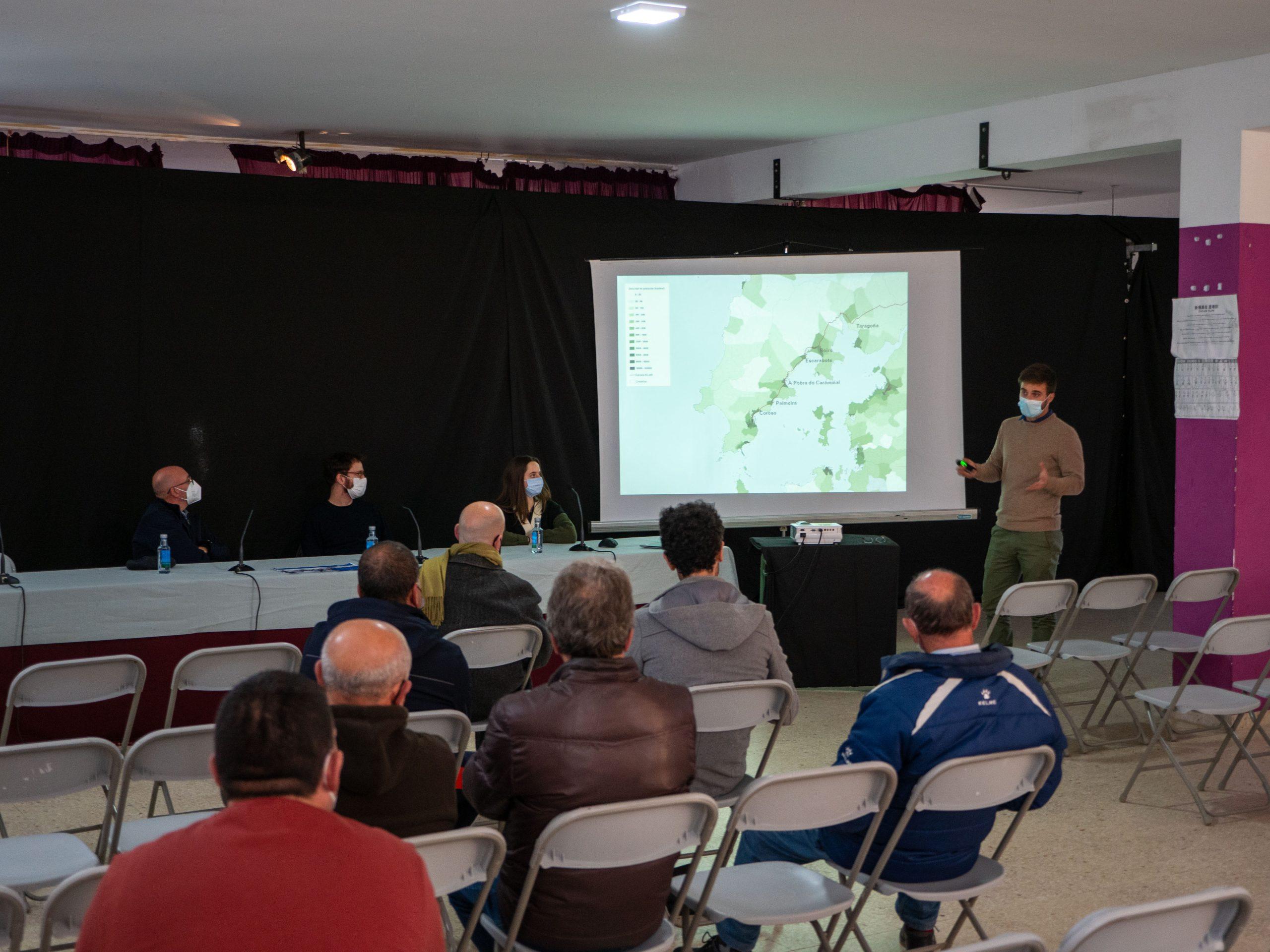
Part of the Fundación RIA team showing audiovisual material to attendees.
In addition, in order to systematically collect the considerations of those attending the event, a survey is distributed. From it, several conclusions are drawn on the use they made of the Campo de Pazos and their perception of the AC-305 as it passes through it.
Most of the attendees (14 residents) travel along Campo de Pazos both on foot and in their own vehicles, mainly to shop in local establishments. Among the main deficiencies of the section pointed out by the attendees are the dangerousness or the narrowness of the sidewalks. Most of the attendees shared a vision of the future of the section with less traffic, more sidewalks and trees.

Question asked in the survey and its result. [GAL]
Analysis
Once a real and updated cartography of Taragoña has been generated, and after collecting all the information gathered, a series of analyses are carried out to help understand the reality of the area, in order to subsequently make a proposal that best suits the real context and the main needs of the section.
The analytical plans carried out are: mobility generating points, first floor uses, vegetation, street furniture, lighting, supply elements in the public space, crosswalks, traffic direction, parking areas, access, protection elements, accidents, public transport and signaling and speed.
As an example of these analytical maps, we show the map referring to traffic directions where the direction allowed in each road is indicated, describing the current mobility by car and the preference for this method of transport when making a trip.
In general, there are two differentiations in terms of traffic direction: two lanes with one direction each and one lane with two directions.
The type of road with two lanes and one direction in each lane corresponds to the analyzed road, the AC-305, and with the important incorporations to it. These incorporations are the road that connects Taragoña with Rianxo and Taragoña with Ribeira and Padrón by means of the AG-11.
The one-lane, two-way road is connected to secondary roads and paths, which serve the inhabitants of Taragoña to reach different points, such as schools, private homes, facilities and farming areas.
Finally, different diagnostic tables are drawn up, showing the relationship between weaknesses, threats, strengths and opportunities based on the analysis prepared and combined with the results obtained in the different meetings with people from the local community.

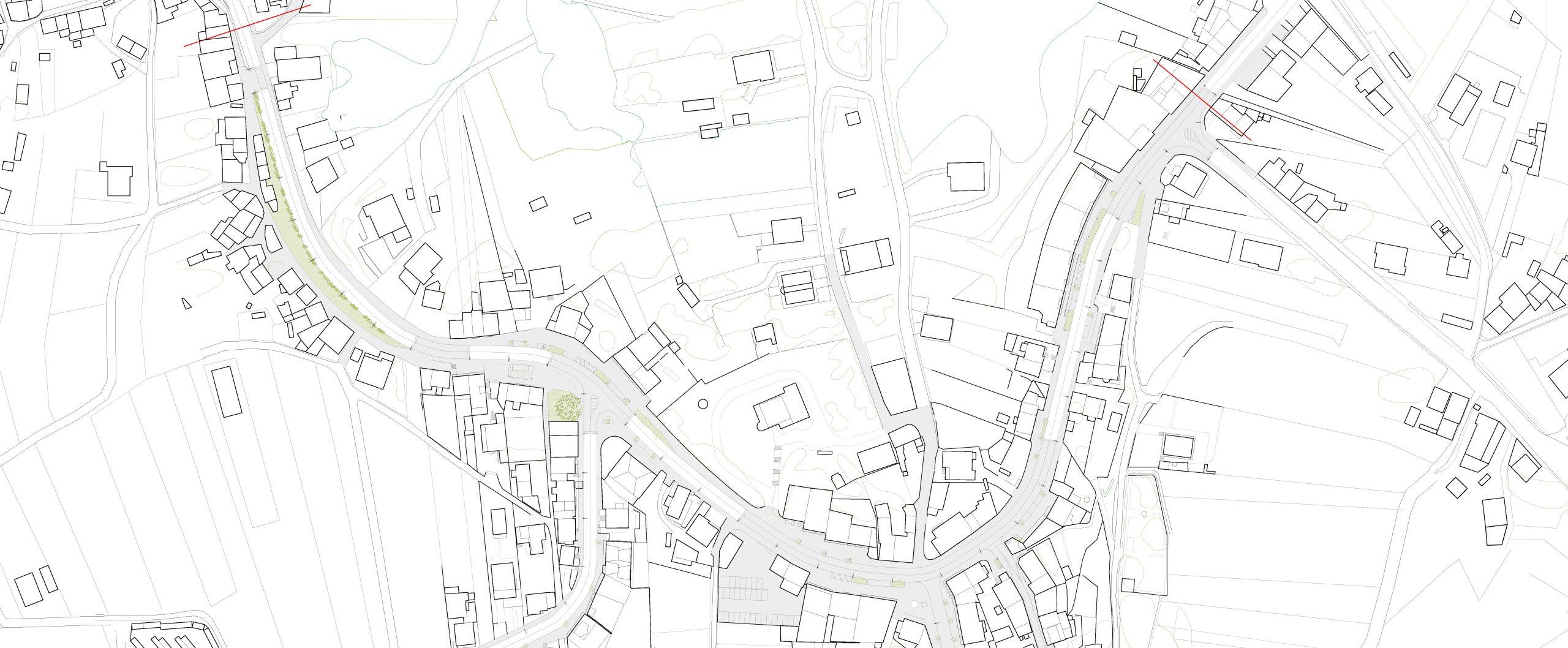
Proposal
The starting point in the urban section of Taragoña is similar to the section of the AC-305 as it passes through Palmeira: a public space designed around the vehicle, with a predominance of surfaces dedicated to road traffic. In addition, the punctual implementation of services and other infrastructural elements, following the logic of immediacy and ease of execution, has resulted in the fragmentation of the space for people, which is currently relegated to a secondary place and is the result of the actions previously described.
The proposal aims to convert this section, currently a road, into a street. The objective is to recover the space and its character as a slow road, silencing the infrastructure to give back the protagonism to the people who live and work there.
Based on the analysis carried out, a series of action strategies are established that seek to take advantage of the identified potentials and combat the existing deficiencies in the studied section. In general, the aim is to guarantee the safety of road users and reinforce the urban identity of the center, recovering the residential and business attractiveness, giving priority to pedestrians and promoting non-motorized internal displacements.
Summary of the proposal
The main criterion for delimiting the scope of action is that the space is contained between facades or closures of individuals, being located between kilometer point 15 + 040 and kilometer point 15 + 760. At intersections and detours, the delimitation will extend between 2 and 3 meters in the direction of the intersection generally.
Exceptionally, this delimitation will be extended transversally when the crossing has a nearby closure (in which case it would be valued as a façade), when actions are proposed that extend transversally (such as crossings, single platforms, alignments and urbanization of public spaces) and, finally, when there are nearby elements or places of special interest (facilities, already consolidated public spaces, heritage elements, etc.).
Performance strategies
Strategy to reinforce mainstreaming
Three different types of cross-cutting situations are identified, depending on several factors: the existence of road crossings and the distance of stores and facilities from the axis of the road.
In cross: It occurs mainly in the central area of the section, coinciding with the square. This point is the only one where there is a crossing of four roads, besides being a very important point since it is the center of Taragoña, therefore, the transversality has to be greater.
In "T": It occurs in the rest of the crossings that exist in the analyzed section, when the intersection only occurs to one side.
Parallel: Occurring in the rest of the cases, where there is no crossing and the potential transversality occurs between sidewalks or opposite sides of the AC-305.
Strategy for reducing maximum speed in urban areas
In order to recover the character of a street, a slow road, and thus create the appropriate framework for more friendly and recognizable spaces for people, it is necessary to reduce the average speed, also seeking to improve the safety of pedestrians and drivers. The speed allowed on the AC-305 section is currently 50 km/h and it is proposed to reduce it to 30 km/h along the entire route.
As an additional recommendation, it is proposed to reduce the permitted speed even further in the central curve to ensure the relationship between both sides of AC-305, pedestrian safety and the reduction of traffic accidents.
With the speed reduction, the time it takes to cross the stretch does not increase drastically with the changes introduced. This time difference does not increase by even one minute.

Strategy for improving accessibility and continuity of public space
The main objective is to ensure a continuous and accessible route on the north sidewalk, since it does not present as many slopes and intersections as the south sidewalk.
The strategy seeks to create transversal connection points in the areas where there is a single platform, to connect with the southern area of Taragoña. After the realignment, the crosswalk area is always greater than 2 meters in the accessible section.
Road space reduction strategy
The aim is to reverse the percentage of free space occupied by vehicles. As part of the strategy, the creation of single platforms is proposed as a tool for creating space for pedestrians at the points where cross-crossing is most necessary.
New areas are contemplated and rearranged for neighbors to meet. In addition, it seeks to consolidate and offer more pedestrian outdoor space in front of the stores, which allows in the case of hospitality use to offer terraces and create small relationship points along the stretch.

Road space reduction strategy.


