
AMOSAR: Accessibility and sustainable mobility in rural areas
AMOSAR: Accessibility and sustainable mobility in rural areas, is a project developed by Fundación RIA with the aim of providing the citizens of the north coast of the Arousa estuary with efficient, sustainable and accessible mobility for their daily movements, improving the connection between the different towns in the region and between these and Santiago de Compostela.

Virtual image of the proposal for sustainable mobility and urban regeneration for the village of Palmeira.
With a total of 66,000 inhabitants, the municipalities of Rianxo, Boiro, A Pobra do Caramiñal and Ribeira, grouped in the Mancomunidad Barbanza Arousa, are promoting an integral project of territorial scope with the aim of economically reactivating this important industrial axis. The objective is to move towards a sustainable urban model and to articulate the region with the main infrastructures of the Atlantic Axis.
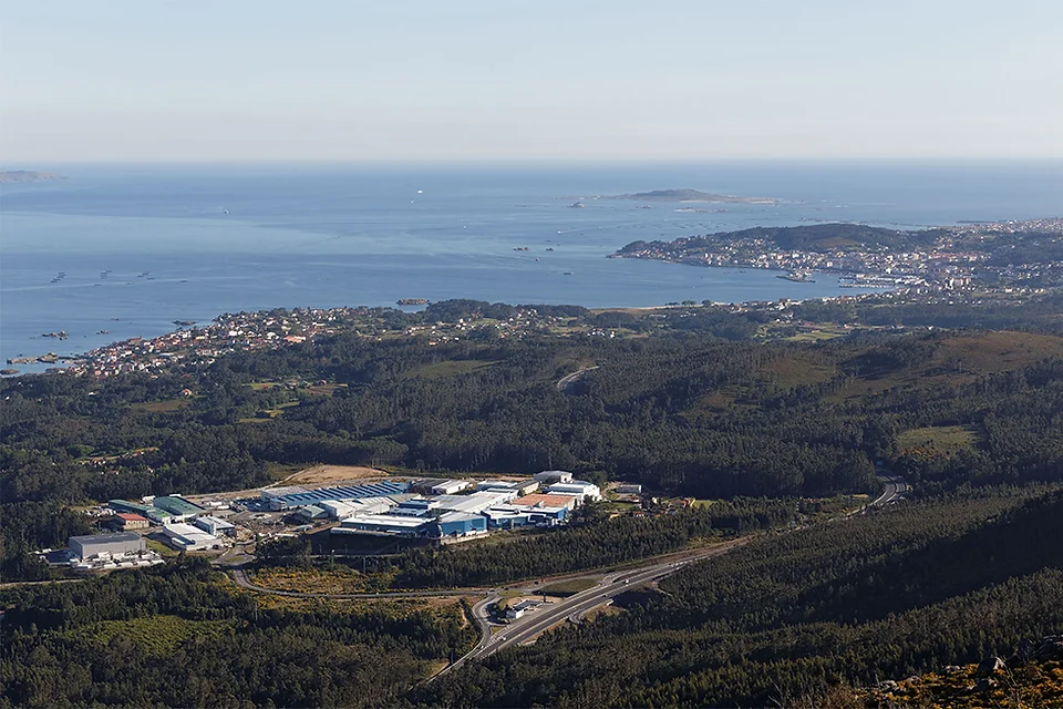
The population centers of Barbanza Arousa are articulated along the north coast of the Arousa estuary and have an economy mainly dependent on the fishing sector. This relationship with the sea has a great influence on local structures, both social and urban. The main economic activities take place in the ports and industrial estates, where leading national companies in the canning sector are located, employing an important part of the local population and therefore generating thousands of daily movements of people and goods.
Year
2021
Promoter
Fundación RIA
Location
Galicia
Team and collaborators
Fundación RIA
Without rail connection, the existing public transport system does not offer an adequate alternative to local mobility demands and leads to dependence on the private vehicle. As a result, the spaces allocated to the vehicle, both for traffic and parking, in many cases occupy most of the public space. This has an obvious negative impact on the built environment of urban centers and also causes serious road safety conflicts in the area.
In addition to this, very permissive planning and the consequent uncontrolled growth of construction has resulted in a large, diffuse urban continuum, with degraded historic centers with a proliferation of empty buildings, undermining the local identities of the region's nuclei.
AMOSAR is a project that accelerates the reconstruction and transformation of the model through the implementation of a series of lines of action promoted by the Spanish Urban Agenda and the European Green Pact, guidelines aligned with the Sustainable Development Goals of the United Nations.
In order to address the necessary urban regeneration promoted by the Spanish Urban Agenda, the focus must be broadened and a comprehensive strategy must be designed that places public, clean and digital mobility as a vector of development, in combination with housing rehabilitation, energy generation and efficiency, and improvement of public space.
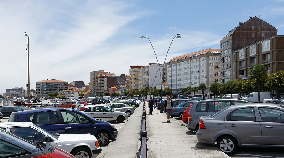
Spaces allocated to vehicles, both for traffic and parking, in many cases occupy most of the public space.
Barbanza Arousa is a supramunicipal area with the third highest population density in the province of A Coruña. It is a territory with an important industrial fabric, in which there are leading companies at national level in the canning sector.
The large number of jobs in these centers substantially increases the number of commuting trips that occur daily in the region, most of them in private combustion vehicles. AMOSAR addresses three major mobility challenges in Barbanza Arousa:
Coordinate a territorial transportation model with environmental requirements.
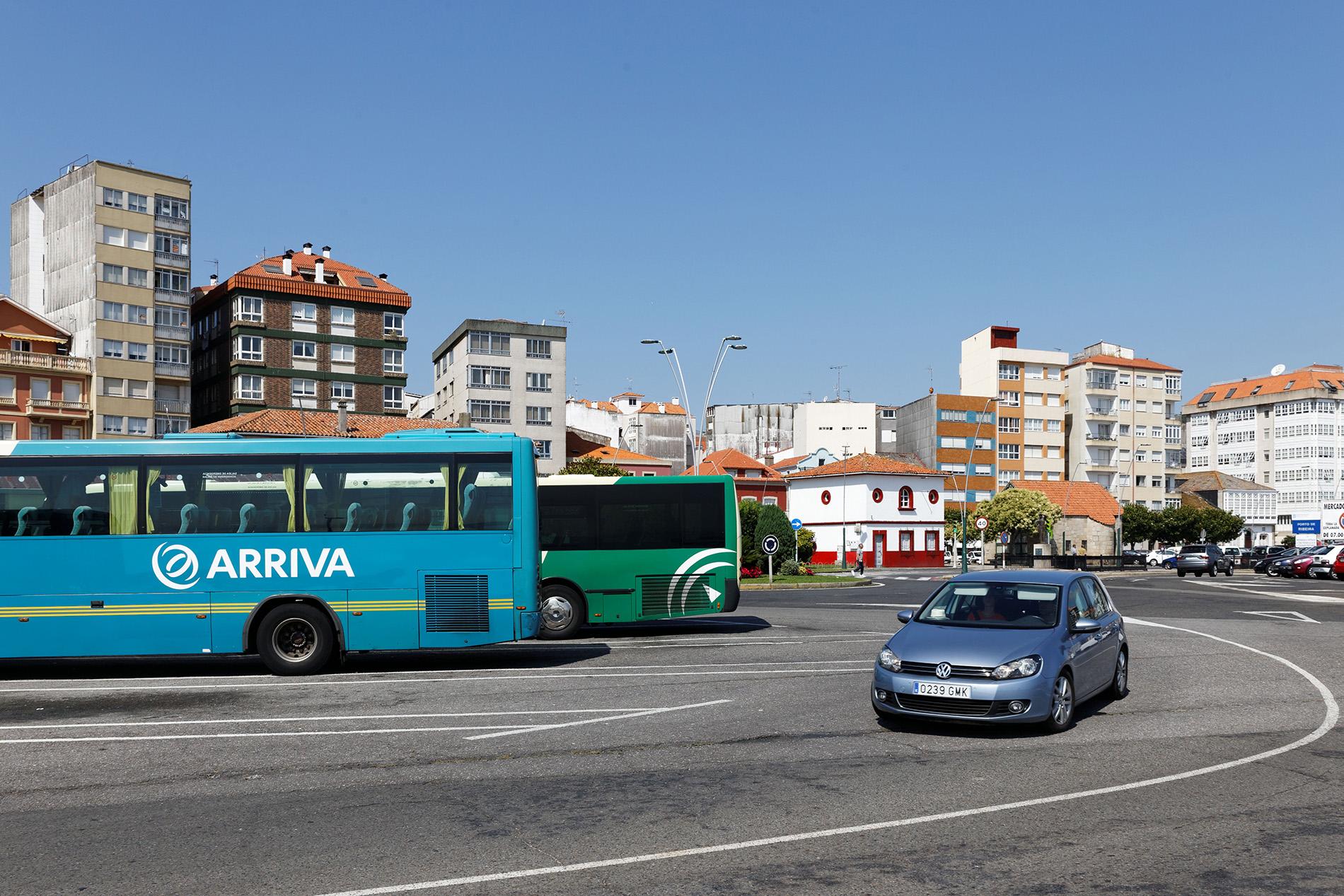
The current public transport system in the region is inefficient and unattractive, being configured as a sum of local services, uncoordinated connections, a multitude of stops and even duplicated routes. In addition, the vehicle fleet of the operating companies is obsolete, polluting and poorly adapted to the current context. The requirements of the route concessions for this region, renewed in 2020 and with a duration of 10 years, have no impact on sustainability, which prevents progressive progress towards a cleaner model. Ultimately, this is a drag on economic development and compromises entrepreneurship and population fixation.
Reducing the impact and dependence on private vehicles
The lack of efficient alternatives for getting around generates a high dependence on private vehicles, which translates into heavy traffic and an over-occupation of public space to the detriment of pedestrian safety and well-being. The infrastructural nature of the roads divides the towns and large parking areas occupy public space, especially the seafronts. The negative impact is not only reflected in the degradation of the built environment and the loss of urban identity, but also in the saturation of industrial parks, especially when workers change shifts, which requires large areas to be set aside for parking.
Ensuring access to information
Another major drawback of the public transport model is the poor accessibility and lack of information offered to users. Today, the most widely used platforms for planning trips (Google Maps) do not include information on public transportation in the region. This fact excludes hundreds of potential travelers interested in sustainable and efficient alternatives and hinders the mobility of people without access to a private vehicle or without a driver's license: young people, the elderly, people with few resources, etc.
An extemporaneous transportation model hinders the transition to more sustainable and efficient mobility models.
Currently, the citizens of the Barbanza peninsula rely heavily on private vehicles to get around.
Location of the industrial estates with respect to the ports of Barbanza Arousa.
A new public transportation model
AMOSAR takes advantage of the opportunity of the proximity of Barbanza Arousa to the Atlantic Axis infrastructures, complementing the existing public transport offer, reducing travel times to these infrastructures and reinforcing the frequency of connections with them.
The settlements in which the project is developed form an economic and social axis parallel to the north coast of the Arousa estuary. This axis is located between the capital of Galicia, Santiago de Compostela, and the regional capital, Ribeira. The distance between the two is less than 80 kilometers.
The proposal seeks to provide efficient, universal and clean mobility for the four municipalities of the supramunicipal area Barbaza Arousa (Rianxo, Boiro, A Pobra do Caramiñal and Ribeira), while providing the northern bank of the Arousa estuary with a fast connection to Padrón and Santiago de Compostela, which unlike the southern bank has no railroad and its only expressway, the AG-11, was inaugurated in 2011.
Existing public transportation supply
The current offer does not satisfy all the potential demand, since its design is based on data on the use of public transport in the region in previous years. Of all the lines that connect with the regional capital, the most direct one has 35 stops, uses 55-seater coaches and runs along the narrow urban road AC-305. Half of the more than 50 lines in operation are school lines for shared public use.
The so-called Atlantic Axis, which connects the Galician cities of Vigo, Pontevedra, Vilagarcía, Santiago A Coruña and Ferrol via the AP-9 highway and a high-speed rail corridor runs very close to Barbanza Arousa, but does not enter the region. Both infrastructures play a central role in the transport of passengers and goods in the community and their proximity represents a great opportunity. AMOSAR takes advantage of this opportunity by complementing the existing public transport offer, reducing travel times to these infrastructures and reinforcing the frequency of connections with them.
Mobility generators
Each of the four municipalities that make up Barbanza Arousa has at least one industrial estate, a port, an urban center with a multitude of facilities, educational and health centers, etc. All this produces a great amount of daily displacements that increase even more during the summer due to the tourist attraction of the beaches of the area and the proximity of Santiago de Compostela. AMOSAR is committed to reduce the dependence on private vehicles and to channel these displacements through other alternative modes of transport, relying on an efficient and sustainable public transport service.
The central role of the AG-11 highway in the public mobility network proposed by AMOSAR allows for a substantial reduction in current travel times, especially between Barbanza Arousa and Santiago.
Road infrastructures
The Barbanza Highway (AG-11) runs at approximately 100 meters above sea level and is the vector of economic development of the industrial estates and business parks. At present, public transport in this region does not use this expressway, and therefore can hardly compete with private transport in terms of travel time.
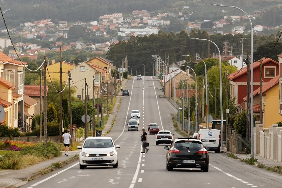
The coastal road (AC-305) is the historic road that crosses and connects the urban centers parallel to and close to the coast. It is a narrow road infrastructure with a higher volume of traffic than would be expected in an urban center of the size of the existing ones and in which the private vehicle predominates in the public space.
Public spaces
The AC-305 is not only a connecting road between the coastal towns of Barbanza Arousa, but also the gateway to them. AMOSAR includes urban regeneration operations to integrate the AC-305 into the urban centers it crosses and turn it into a safe, accessible and attractive public space.
Transport information
AMOSAR is possible thanks to the digitization of information on transport and mobility to plan public transport services efficiently, promote their use and accessibility by citizens, and facilitate their management by operators, through the implementation of Operational Support Systems (OSS).
Vehicles
A fleet of 15 low-emission vehicles and 30 drivers will ensure minimum waiting times at interchanges and trip frequencies appropriate to the needs of trip generators.

The central role of the AG-11 highway in the public mobility network proposed by AMOSAR allows for a substantial reduction in current travel times, especially between Barbanza Arousa and Santiago.
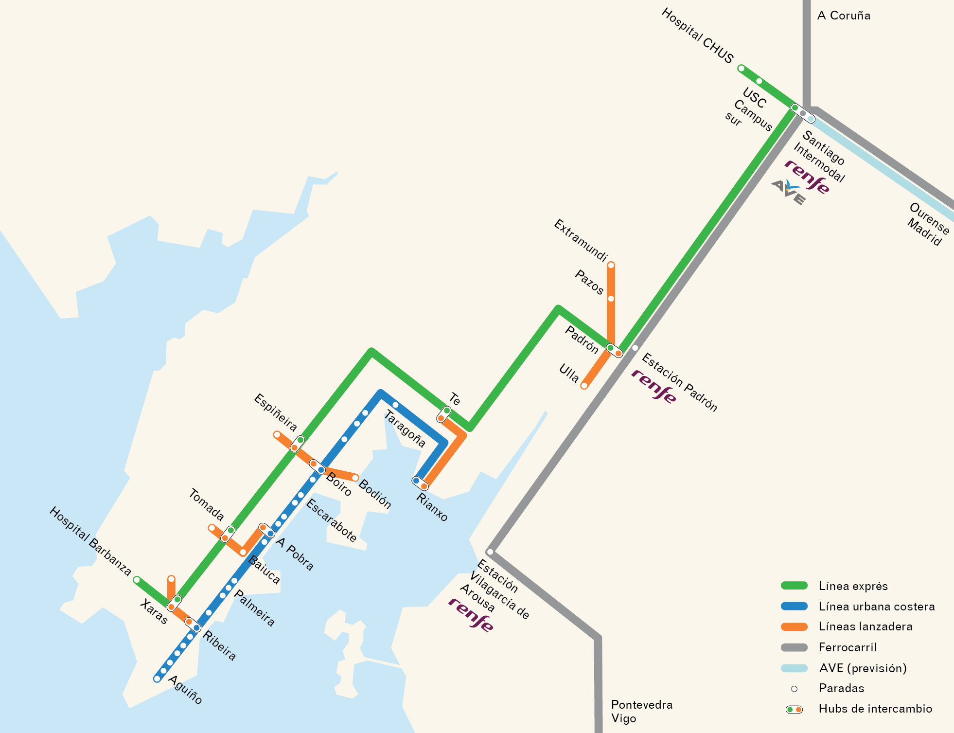
Lines
A network of 7 lines responds to local needs and seeks to make up for the shortcomings of the existing public transport system. It is a public mobility model based on information, with very short waiting and interchange times, with real-time information for passengers and operators.
The express line (green) connects the municipalities with each other and with the regional capital, Santiago de Compostela, in a one-hour trip via the Atlantic Highway (AP-9) and the Barbanza Highway (AG-11). The direct connections to the AG-11 and the availability of land in the industrial estates are used to locate the hubs.
The coastal line (blue) runs along the coastal settlements, from Aguiño to Rianxo, with smaller vehicles and higher frequencies, to adapt to the conditions of the narrow road along which it runs and which connects all the coastal settlements, the AC-305.
Shuttle lines (orange) make it possible to fill a closed system. The function of these lines is to connect in a coordinated manner the express and coastal lines, with the generalized use of SAEs, by means of hubs, or interchange nodes.
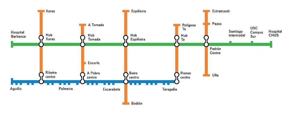
Exchange hubs
Interchange hubs are express line stops, strategically located on available land in industrial estates and business parks. These hubs, in addition to connecting the express line with the centers of the municipalities, are infrastructures that integrate other non-motorized means of transport, park-and-ride lots and charging stations to promote intermodality.
Stops
Two types of stops are used along the coastline. The light canopy typology is reserved for larger environments and for areas identified for urban improvement projects. The signpost typology is intended for some sections of the coastline roadway where space constraints exist. In both cases the stops will display information about the line in real time maintaining the same level of information without depending on the typology.
AMOSAR is a supramunicipal project supported by the municipalities of Rianxo, Boiro, A Pobra do Caramiñal and Ribeira, which are grouped together in the Mancomunidad Barbanza Arousa.


