
From road to street (I): Analysis of the AC-305 road for the identification of urban integration sections.
The study of the AC-305 road seeks to establish a valid and locally contrasted methodology for the analysis of roads in urban sections, which will be the basis for subsequent intervention strategies, replicable and therefore extrapolable to other places, and for urbanization projects.
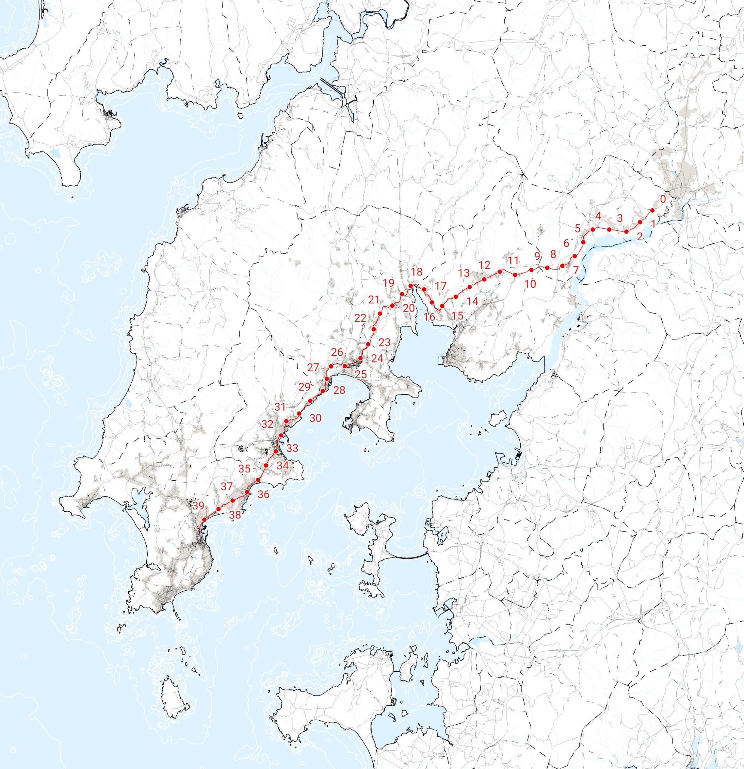
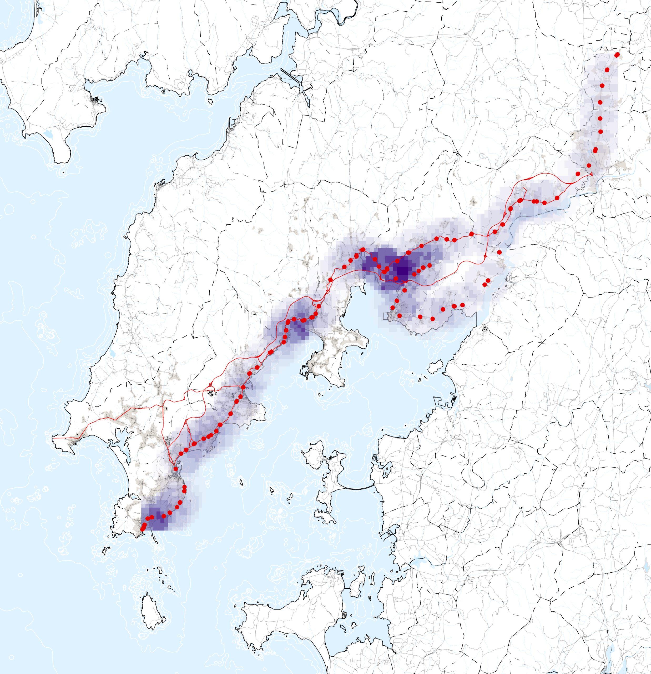
Layout and kilometer points of the AC-305.
The work developed is the result of an agreement between the Axencia Galega de Infraestructuras and Fundación RIA. The first phase consists of a study of conflicts along the AC-305 road, an important axis of the autonomously managed road network, with the aim of identifying sections to intervene later with the design of solutions and proposals to generate a more anthropocentric public space.
The study of the AC-305 road seeks to establish a valid and locally contrasted methodology for the analysis of urban sections, which will be the basis for subsequent intervention strategies and urbanization projects. These strategies, of a replicable nature and therefore extrapolable to other places, will be the framework within which to address the challenges presented in this territory that encompass social, economic and environmental dynamics.
In addition to the development of a methodology for approaching the analysis of environmentally, economically and socially conflictive roads, this study concludes with the identification and preliminary delimitation of five (5) sections in which to develop intervention proposals to improve and provide solutions to the problems detected.
Year
2021
Promoter
Xuntade Galicia - Consellería de Infraestruturas e Mobilidade - Axencia Galega de Infraestruturas
Fundación RIA
Location
OBarbanza, Galicia
Team and collaborators
Fundación RIA
The AC-305 is a space built from the logic of traffic flow and that has pushed away social activities, degrading at the same time the local commercial fabric.
If we compare the aerial images of the passage of the AC-305 through the coastal nuclei (the American flight of 1956/57 with the PNOA of 2017), we can clearly observe the undeniable importance of this infrastructure, which is and has been the vector of development of the northern margin of the Arousa estuary. However, although the AC-305 continues to play a fundamental role the development of this territory, it is not based on the same principles as a century ago. While at the beginning the AC-305 was conceived as little more than a dirt road parallel to the coast, which would also become the main street of the towns it crossed, it quickly became a key infrastructure for the growth of fishing and canning activity (initially on the seafront). This transformation responded to the needs of an industry that based its growth on the transport of its products to other nearby markets by land. The same happened in the fronts and port areas of the fishing villages in the north of the estuary, which were drastically transformed into small and medium-sized industrial areas. From that moment on, the AC-305, that road of contained section that was basically the extension of the main streets of the nuclei, began to integrate and articulate most of the new residential and commercial building developments on the coast.
With the growth of fishing activity, conflicts along the AC-305 also grow: uses (residential, commercial and industrial) and very different needs converge in a very limited physical space. While industrial uses present the need for road infrastructures of generous section and smoothed layouts that allow fast heavy vehicle traffic, the needs of most of the remaining uses require a smaller scale treatment and an approach that takes into account the human scale.
Without a logistic alternative such as the railroad in this region, the response to these conflicts is the creation of a fast road (currently AG-11) that assumes a large part of the heavy and light long-distance traffic from the coastal towns. It is precisely the consolidation of this fast infrastructure, together with the economic change in favor of the tertiary sector, which accelerates the following transformation: the hegemony of the private vehicle in the layout of the AC-305. With the disappearance of much of the heavy traffic and the cessation of fishing activity in many ports of small towns, the private vehicle "colonizes" the public space. This fact is even more accentuated if possible without the pertinent policies of sustainable mobility or universal accessibility that can offer an alternative to the mobility of the population. This colonization of space by the private vehicle is a typical and symptomatic situation of territorial contexts that have overcome industrialism as it was conceived, and that, as also happens in port landfills, has an obvious impact on much of the layout of the AC-305 and presents two problems that are the reason and the starting point of this study.
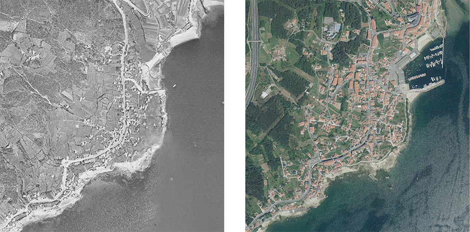
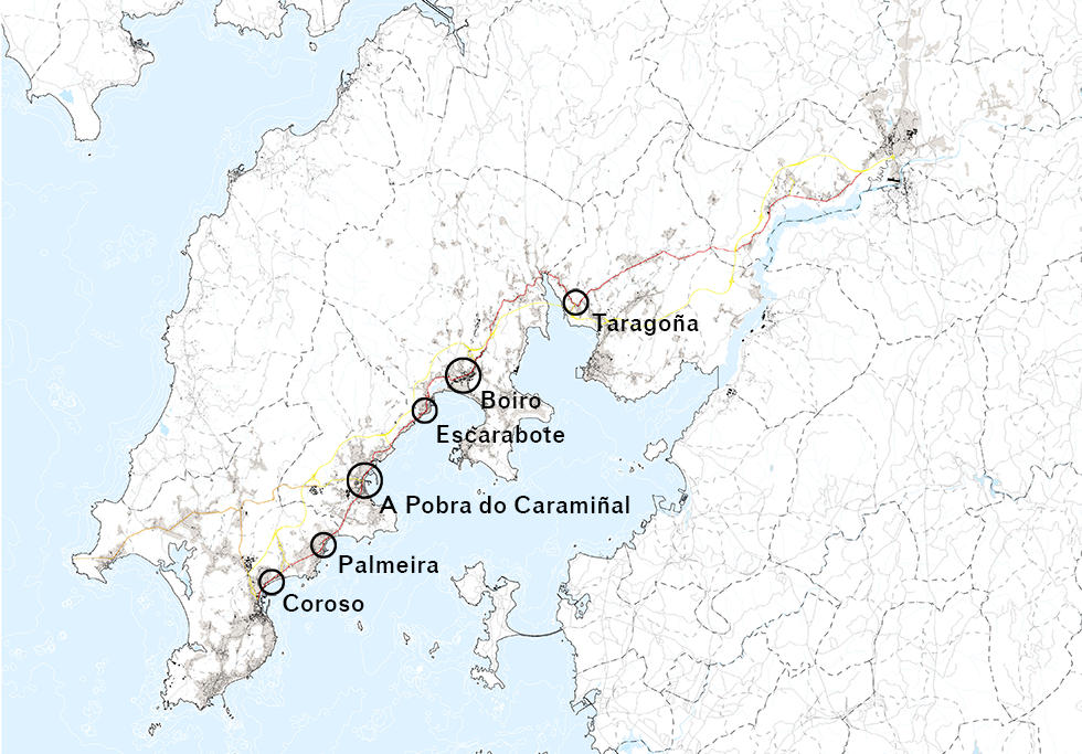
Evolution of the Escarabote nucleus along the AC-305.

Historical photograph of Venecia street in Santa Uxía de Ribeira.
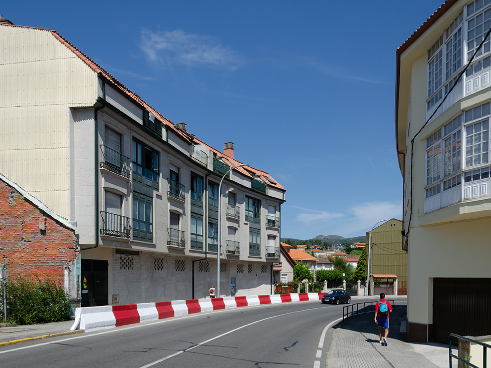
Current photograph of the AC-305 in Palmeira.
The transformation of the space between buildings, based solely on pragmatic criteria, leads to the disappearance of the concept of public space, which gives way in favor of fast, dense traffic and large parking areas. Public space for people is relegated to the background and leads to multiple conflicts. Likewise, the danger and the number of accidents in the most urban and smaller sections is increased and represents a serious problem for citizens. The loss of real estate value of roadside buildings, or the multitude of empty commercial first floors in their vicinity, is notable.
The street, the social space par excellence, which acted as an attractor and stitched the urban fabric together, as well as connecting it with neighboring centers, becomes a segregating element, a barrier that divides urban centers in two, and eliminates the urban identity of the place. By segregation we mean the opposition of traffic to the transversal route between activities on both facades, evidence of a living and humanized space, as can be seen in the fieldwork notes of Jan Gehl's The Humanization of Urban Space. Regarding the problem of vehicular traffic, it is necessary to differentiate between street and road, since this segregation does not have the same transcendence in the roads that support the dispersed fabric.
The analysis of the study area is based on the georeferencing of information obtained from official sources and direct observation processes.
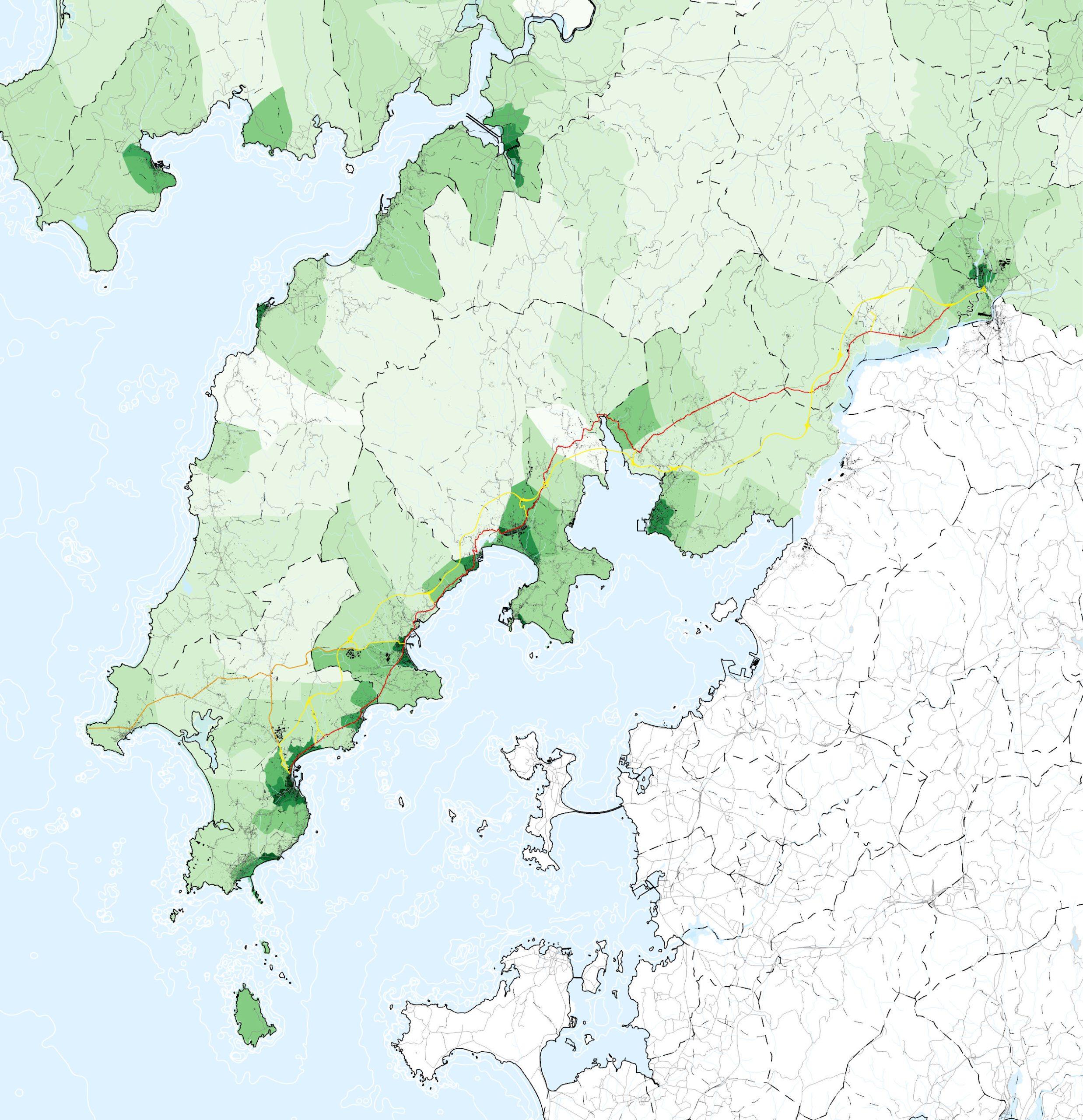
With this starting situation, a layered analysis of the data obtained is proposed, with the objective of disaggregating some previously identified factors that influence the study area. We chose to graphically represent the data separately to facilitate the reading and understanding of the impact of each of the indicators. This segregation does not mean that what is obvious is ignored: that there is an overlapping and convergence of these impacts and effects occurring in the same physical space. It is, in fact, this overlapping that is the basis on which areas of conflict are identified and translated into sections, given the nature of the work, as well as the smaller scale analysis with which the priority with which they need to be addressed is determined.
The method used for the analysis of the study area is based on the georeferencing of data obtained from official sources, which yield information about a series of previously agreed indicators, as well as the observation of the resulting cartographies and the creation of combined or derived cartographies of the former.
A selection of indicators is established to determine the data and sources necessary for the global analysis, always bearing in mind the objective of the study: the delimitation of sections susceptible to intervention for the recovery of their human character. Among the indicators selected are the length of the road, location with respect to urban centers, location of the road with respect to the main geographical landmarks, dimensions, typologies and character of the road section, use of the road, permitted speeds, daily intermunicipal travel flows, accidents, mortality, population density, location, quantity and density of activity and travel generators, location of coastal identity nuclei, accessibility to public transport, areas of noise pollution, and, finally, delimitation and definition of crossings and urban sections.
Subsequently, the data sources are located, most of them are official sources of public administration entities, and, in case the data are not available, they will be produced internally through direct observation. After obtaining the information and data, they will be georeferenced with the aim of producing the cartographies, i.e. contextualizing the data obtained.
Once the resulting cartographies have been obtained and, consequently, the data analysis according to the selected indicators, a more detailed correction of the preliminary delimitation of sections is carried out, an analytical process that uses additional criteria to those already established. In this case, the criteria are intended to be followed through a previously prepared and delimited observation and fieldwork exercise. Issues such as visual landmarks, which are only visible at street level, conflict situations or even something much more subjective such as the character of the space, should not be left aside when one wants to intervene in public space, and are difficult to appreciate from a cartography.

Population density by census tract.
Gauging on the structuring roads of the coast.

Density of public transportation stops.
Daily mobility routes.
Delimitation of the scope of the action sections and definition of intervention strategies in the public space.
The choice of starting and ending points for the sections is based on several factors, from current planning to local dynamics, extracted from direct observations during field visits. The proposed start and end points are preliminary and should be reaffirmed or modified in the detailed studies of each section.
Once the sections have been delimited, a comparative analysis is carried out with the objective of limiting to a first phase of five the number of intervention areas for which detailed studies will be developed. In order to obtain a comparative diagnosis, a system of numerical values is used to unify and compare the quantitative and qualitative data of the analyses previously developed and presented.
Based on the analysis carried out, a series of action strategies are established which seek to take advantage of the identified potentials and combat the existing deficiencies in the section studied. The guidelines are aimed at transforming the road into a street when it crosses a nucleus or settlement, since these are the sections with the highest density of inhabitants and activities. This fact, which makes them destinations and origins of mobility, differs from the current condition of transit areas, a consequence of the configuration of the free space between facades and the gradual disappearance of commercial uses and offices on the first floors. In general terms, the aim is to guarantee the safety of road users and to reinforce the urban identity of the center. The aim is to recover residential and business activity by giving priority to pedestrians and promoting non-motorized interior travel.
The strategies seek to transform the road into a street when it crosses a nucleus or settlement, since it is these sections that bring together a higher density of inhabitants and activities. This fact, which converts them into destinations and origins of mobility, differs from the current condition of areas for passing traffic, a consequence of the configuration of the free space between facades and the gradual disappearance of commercial uses and offices on the first floors. With the transformation of the road into a street, the aim is to guarantee the safety of all road users and promote mobility on foot in the center. All this with the aim of creating common public spaces, important places in the local imaginary, which help to reinforce the identity of each nucleus.
Identification of the sections of action.

Design of implementation strategies in the identified sections.


